Property Record
2780 Horizon Ridge Ct, Suwanee, GA 30024
NEARBY LISTINGS FOR SALE OR LEASE
Property Detail
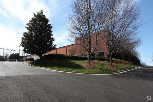
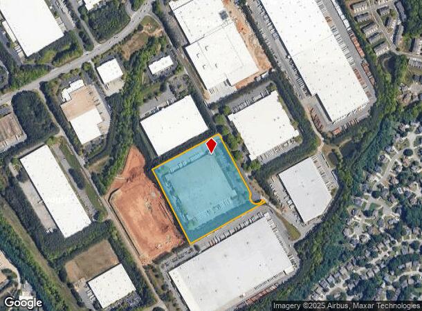
2780 Horizon Ridge Ct
Atlanta-Sandy Springs-Roswell, GA
Horizon Tech & Dist Pk 3
7-150-070
L9 BA HORIZON TECH & DIST PK 3
Warehouse
Gwinnett
X
Georgia
13135C0044F
9
2025
12.70 AC
2025
Duluth/Suwanee/Buford
050565
Atlanta
214,528 SF
DEMOGRAPHICS near 2780 Horizon Ridge Ct
1 mile
3 mile
5 mile
2024 Total Population
5,415
65,518
182,408
2029 Population
5,602
68,377
191,019
Pop Growth 2024-2029
+ 3.45%
+ 4.36%
+ 4.72%
Average Age
40
39
38
2024 Total Households
1,764
21,977
62,365
HH Growth 2024-2029
+ 3.57%
+ 4.60%
+ 4.86%
Median Household Inc
$101,765
$96,683
$86,336
Avg Household Size
3.00
2.90
2.90
2024 Avg HH Vehicles
2.00
2.00
2.00
Median Home Value
$294,215
$320,670
$340,453
Median Year Built
1993
1995
1997
Nearby Places
Map Layers
Map Styles
 Street
 Aerial
Transit
 Traffic
 Biking
Places
Listings with unknown addresses are not visible on the map
- Restaurants
- Banks
- Shops
- Fitness
- Groceries
SALE & LEASE HISTORY
LISTING DATE
SALE/LEASE

Sep 26, 2016
For Lease
Sep 24, 2016
For Lease
Nearby Properties
Address
Land Use
TOTAL SIZE
Lot Size
Zoning
Address
Land Use
TOTAL SIZE
Lot Size
Zoning
563,718 SF
41.75 AC
RM13
Address
Land Use
TOTAL SIZE
Lot Size
Zoning
419,467 SF
665.75 AC
RZT
Address
Land Use
TOTAL SIZE
Lot Size
Zoning
455,605 SF
33.93 AC
RM13
Address
Land Use
TOTAL SIZE
Lot Size
Zoning
415,963 SF
48.86 AC
RM10
Address
Land Use
TOTAL SIZE
Lot Size
Zoning
461,593 SF
14.11 AC
MUR
Address
Land Use
TOTAL SIZE
Lot Size
Zoning
379,183 SF
6.09 AC
PMUD
Address
Land Use
TOTAL SIZE
Lot Size
Zoning
415,609 SF
16.50 AC
RM24
Address
Land Use
TOTAL SIZE
Lot Size
Zoning
367,419 SF
17.06 AC
RM24
Address
Land Use
TOTAL SIZE
Lot Size
Zoning
304,276 SF
14.90 AC
MUR
Address
Land Use
TOTAL SIZE
Lot Size
Zoning
439,723 SF
64.56 AC
R100
Address
Land Use
TOTAL SIZE
Lot Size
Zoning
428,329 SF
18.44 AC
RM24
Address
Land Use
TOTAL SIZE
Lot Size
Zoning
282,431 SF
23.20 AC
RM13
Address
Land Use
TOTAL SIZE
Lot Size
Zoning
282,630 SF
11.83 AC
MUO
Address
Land Use
TOTAL SIZE
Lot Size
Zoning
220,779 SF
7.32 AC
PMUD
Address
Land Use
TOTAL SIZE
Lot Size
Zoning
514,956 SF
47.21 AC
M1
Address
Land Use
TOTAL SIZE
Lot Size
Zoning
385,167 SF
49.55 AC
M1
Address
Land Use
TOTAL SIZE
Lot Size
Zoning
503,650 SF
34.37 AC
M1
Address
Land Use
TOTAL SIZE
Lot Size
Zoning
332,011 SF
8.84 AC
PMUD
Address
Land Use
TOTAL SIZE
Lot Size
Zoning
102,152 SF
20.95 AC
C2
Address
Land Use
TOTAL SIZE
Lot Size
Zoning
218,583 SF
2.21 AC
MUO
Address
Land Use
TOTAL SIZE
Lot Size
Zoning
6,552 SF
235.95 AC
R140
Address
Land Use
TOTAL SIZE
Lot Size
Zoning
223,096 SF
6.06 AC
MUR
Address
Land Use
TOTAL SIZE
Lot Size
Zoning
661,663 SF
50.64 AC
M1
Address
Land Use
TOTAL SIZE
Lot Size
Zoning
327,360 SF
26.42 AC
M1
Address
Land Use
TOTAL SIZE
Lot Size
Zoning
457,110 SF
22.37 AC
M1
Address
Land Use
TOTAL SIZE
Lot Size
Zoning
553,941 SF
32.82 AC
M1
Address
Land Use
TOTAL SIZE
Lot Size
Zoning
159,547 SF
24.72 AC
R100
Address
Land Use
TOTAL SIZE
Lot Size
Zoning
6,031 SF
120.86 AC
OI
Address
Land Use
TOTAL SIZE
Lot Size
Zoning
597,445 SF
39 AC
M1
Address
Land Use
TOTAL SIZE
Lot Size
Zoning
212,293 SF
2.89 AC
MUR
The World's #1 Commercial Real Estate Marketplace
Connect with us
© 2026 CoStar Group
The information above has been obtained from sources believed reliable. While we do not doubt its accuracy we have not verified it and make no guarantee, warranty or representation about it. It is your responsibility to independently confirm its accuracy and completeness. Any projections, opinions, assumptions, or estimates used are for example only and do not represent the current or future performance of the property. The value of this transaction to you depends on tax and other factors which should be evaluated by your tax, financial, and legal advisors. You and your advisors should conduct a careful, independent investigation of the property to determine to your satisfaction the suitability of the property for your needs.